
Know Your Flood Hazard
You don’t need to live right on the water to be at risk of flooding. Floods are caused by storms, melting snow, hurricanes and water backup due to overloaded drainage systems and dam or levee failures. There are two basic types of flooding that affect our area, coastal flooding and riverine or flash flooding.
Due to our low-lying geography and proximity to the coast, Manasquan is extremely susceptible to coastal flooding. When coastal flooding occurs, water rises along the Atlantic Ocean, Manasquan River and smaller tributaries including Watson’s Creek, Glimmer Glass Harbor, Stockton Lake, Robert Swamp brook, Judas creek, Deep Creek and Mac’s Brook. This rising water overtops dunes, marshes, bulkheads and roadways, overwhelms drainage systems, and inundates surrounding areas.
Hurricanes, tropical storms and strong nor’easters produce a particularly dangerous type of coastal flooding referred to as storm surge. A wall of water sweeps inland with the landfall of the storm and can result in devastating flooding as what was witnessed with Superstorm Sandy in 2012. In addition to storm surge, direct wave attack may further damage homes with coastal frontage during strong coastal storms.
Another common type of flooding that occurs in our area is localized riverine flooding. Constant heavy rainfall produces huge volumes of runoff that can overload drainage systems and can back up into streets and low-lying areas. Homes and businesses can flood, especially in basements and first floors, leaving the community to cope with the problems that result.
Fortunately, there are a number of services available to you in order for you to determine your risk.
For a great resource on flood risk information, please visit the National Flood Insurance Program’s understanding flood risk website.
Elevation Certificates:
An Elevation Certificate is an important tool that documents your building’s elevation. Manasquan’s Construction & Code Department maintains elevation certificates for buildings that have been constructed or substantially improved since 1992. You can request a copy of an Elevation Certificate by contacting the Manasquan Construction & Code Department at (732) 223-0544 ext. 307 or by visiting the second floor of Borough Hall.
Click here to search Manasquan's online database of elevation certificates.
FEMA provides an elevation certificate website with valuable information for homeowners about elevation certificates and flood insurance.
Map Information Service
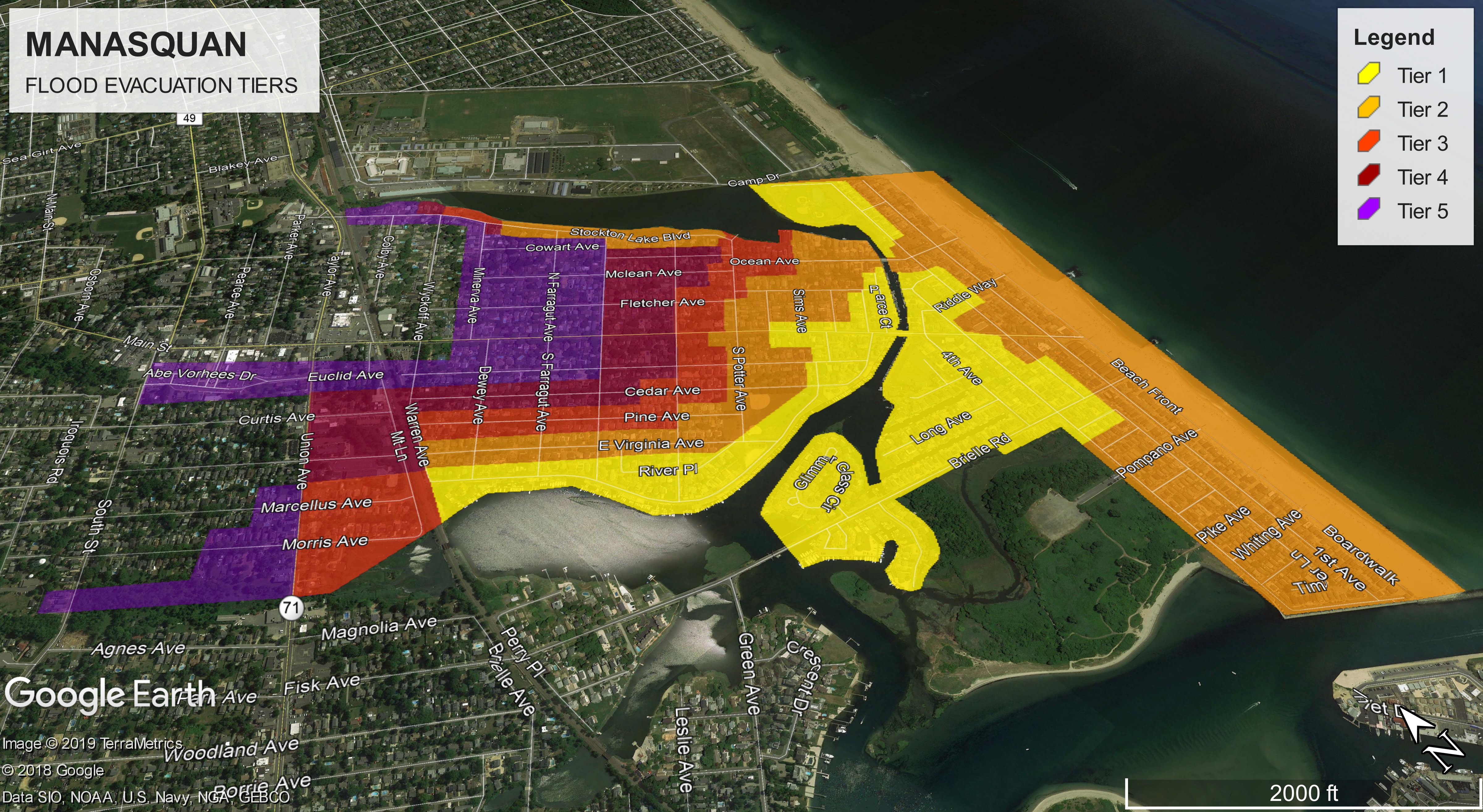
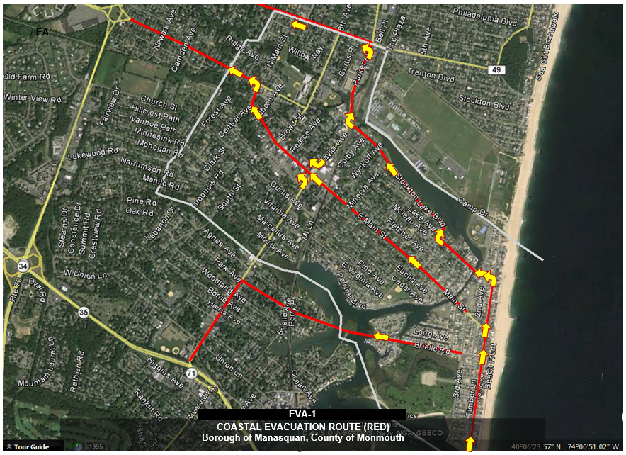
Manasquan’s Construction & Code Department maintains updated Flood Insurance Rate Maps (FIRM’s) as well as mapping that delineates wetlands, coastal high hazard erosion areas, coastal barrier and critical habitat areas, conservation zones, evacuation routes and zones, as well as estimate 100-year flood depths and historical flood mapping. Construction & Code Department Staff can locate your property based upon your address, determine the following:
- If you are in a flood zone or special flood hazard area (SFHA), whether Flood Insurance is required, your base flood elevation (BFE), and whether you are within the limits of moderate wave action (LiMWA) or within a high hazard coastal erosion zone.
- Whether your property is subject to coastal flooding or is within the limits of dam breach or hurricane inundation zones as well the estimated 100-year water depth
- Whether your property is in an undeveloped coastal barrier or otherwise protected Coastal Barrier Resource System (CBRS), in a critical habitat as mapped by the U.S. Fish & Wildlife Service, within a local or regional conservation area or within a designated wetlands or natural floodway.
Monmouth County’s online GIS Mapping:
The Monmouth County CRS Activity 440 Self Service Mapping Application application will allow you to easily visualize data relevant to your floodplain management activities, including:
- AMD1 - The Special Flood Hazard Area (SFHA) boundaries, municipal boundaries, street centerlines, and parcel boundaries
- AMD2 - Building Footprints and SFHA boundaries
- AMD3 - Floodways and coastal high hazard areas with parcels and building footprints
- AMD4 - Base flood elevations in the flood hazard area (SFHA layer)
- AMD5 - FIRM zone attributes (SFHA layer)
- AMD6 - The 500 year floodplain
- AMD7 - The SSURGO Soils layer, NODEP Landslides Data, and NJDEP Tidal Climate Adjusted Flood Elevation
- AMD8 - 2-foot contour lines
- AMD12 - Coastal Barriers Resources System (CBS), wetlands, streams, waterbodies, and habitats
Click here for Guidance for use of the Monmouth County GIS Map tool.
The following online map resources are also available:
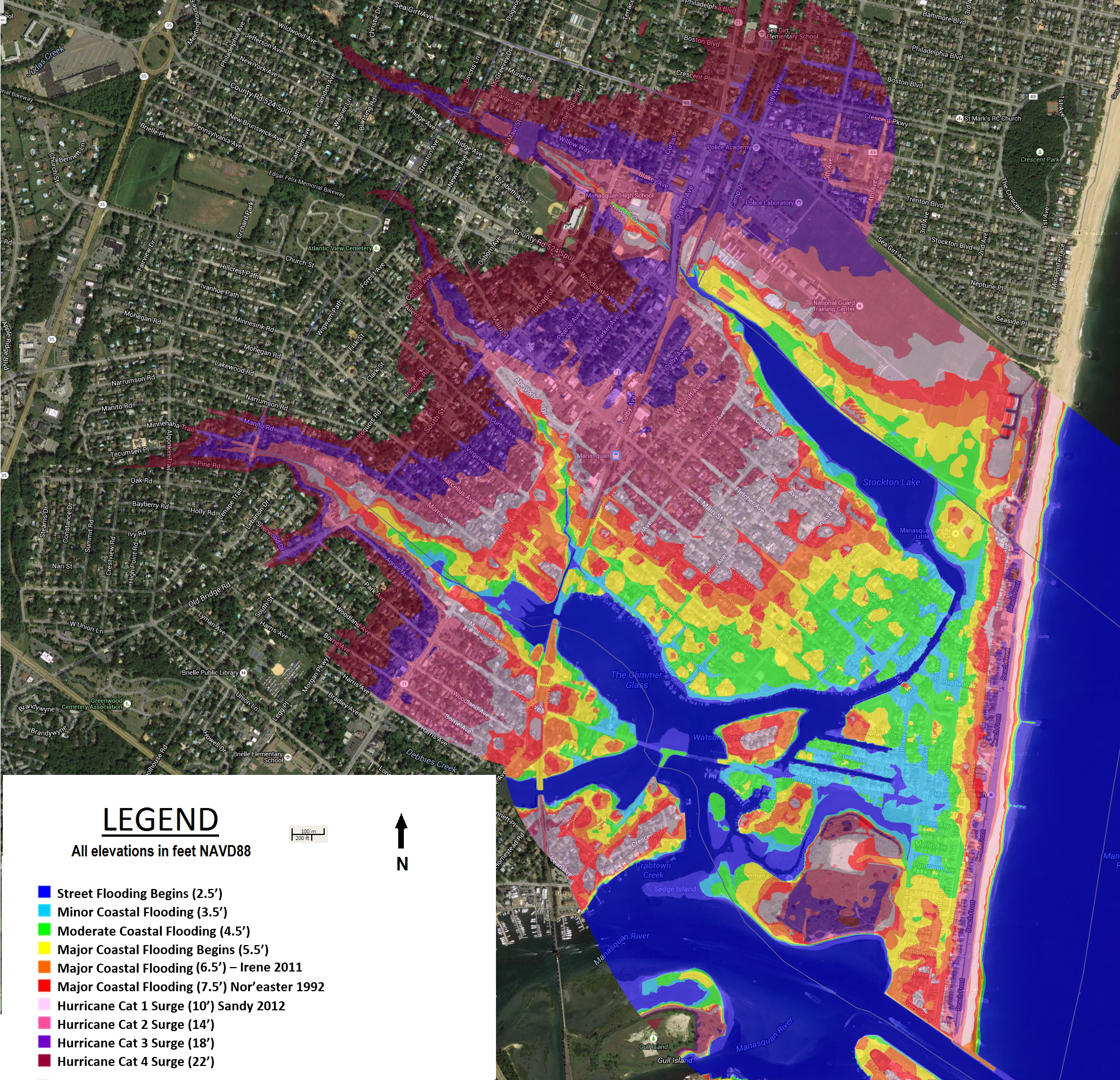
Manasquan's Online Flood and Storm Surge Maps
Monmouth County Coastal Flood Evacuation Zones: http://www.mcsonj.org/knowyourzone/
USGS Superstorm Sandy (10/29/2012) Historical Storm of Record Benchmark Maps https://stn.wim.usgs.gov/fev/#Sandy
NOAA Coastal Flood Exposure Mapper: https://www.coast.noaa.gov/floodexposure/#/select
Rutgers NJ Flood Mapper: https://www.njfloodmapper.org/Flood insurance Rate Maps / Coastal Flood & Hurricane Inundation Areas: https://www.coast.noaa.gov/floodexposure
FEMA FIRM Flood Map Service:
https://msc.fema.gov/portal/home
FEMA Region II: WHAT IS MY BASE FLOOD ELEVATION (BFE)? ADDRESS LOOKUP TOOL:
http://www.region2coastal.com/view-flood-maps-data/what-is-my-bfe-address-lookup-tool/
National Wetlands Inventory:
https://www.fws.gov/wetlands/data/mapper.htmlCoastal Barrier Resources System Mapper:
https://fwsprimary.wim.usgs.gov/cbrs-mapper-v2/
USF&WS Critical Habitat Mapper: http://fws.maps.arcgis.com/home/webmap/viewer.html?webmap=9d8de5e265ad4fe09893cf75b8dbfb77