
Flood Safety
Over 90 percent of Manasquan is in some type of flood inundation area, and flooding affects nearly everyone. Here are some actions you can take to protect yourself, your family and pets from the threats flooding poses:
- Visit https://www.ready.gov/floods for flood safety tips, flood watch & warning information, making an emergency plan and what to do after a flood.
- Please visit the Monmouth County Sherriff’s Office Know Your Zone website to determine if you are in a pre-planned coastal evacuation zone.
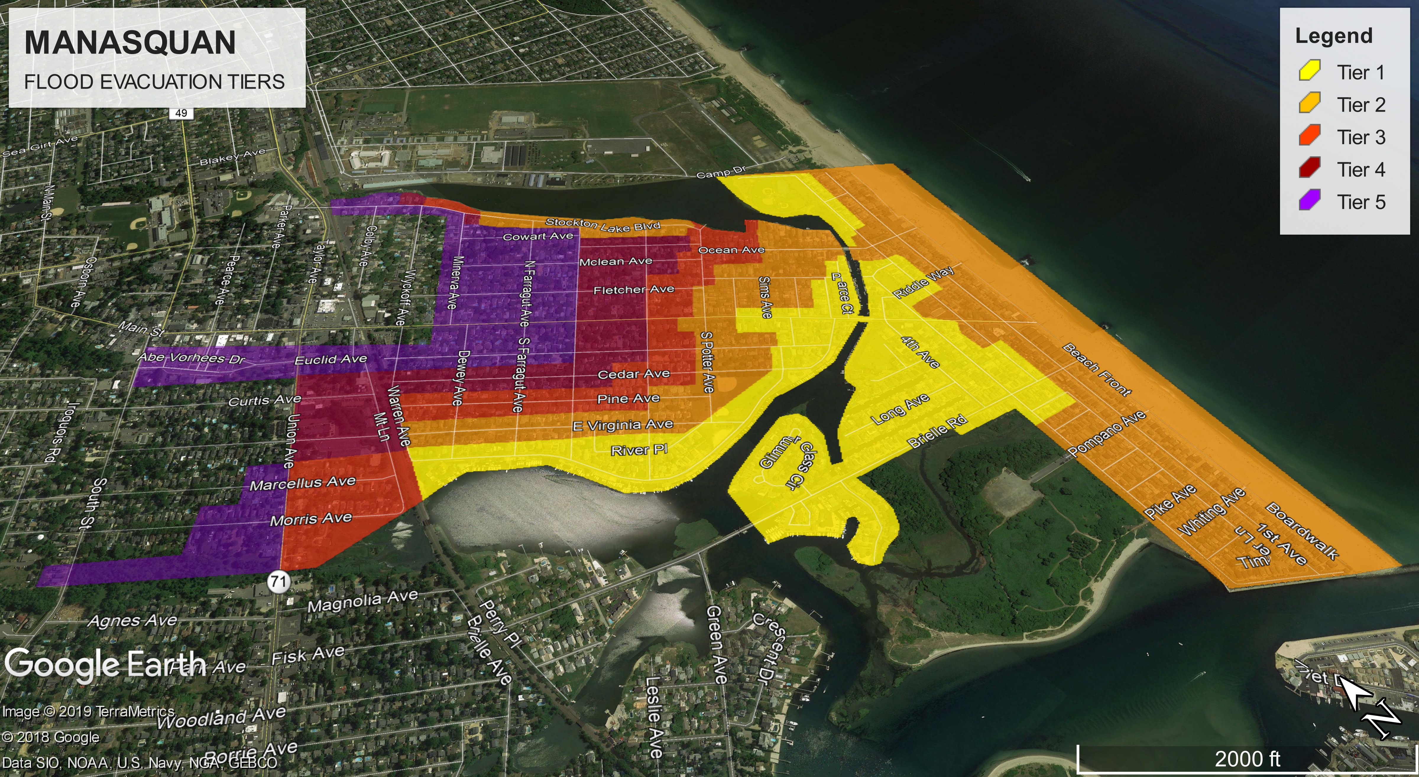
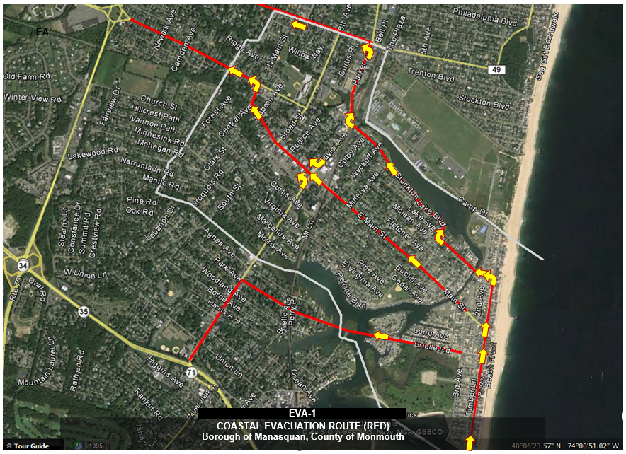
- Familiarize yourself with Manasquan's Evacuation Zones and Manasquan’s evacuation routes.
- Visit Manasquan OEM's Prepare website.
- Purchase a NOAA weather radio for your home or business. NOAA weather radio is a public service provided by both the National Weather Service and the Emergency Alert System, enabling your weather radio to be a single source for comprehensive weather and emergency information. For additional information on NOAA weather radios, visit the National Weather Service at http://www.nws.noaa.gov/nwr/
- Sign up for Manasquan’s Notification System in order to automatically subscribe to alerts from Manasquan’s Office of Emergency Management.
- Stay Informed with the latest Emergency Information on radio station 1620AM, facebook & Twitter
If an evacuation order is issued:
In the event an evacuation is issued, Manasquan will activate its public warning systems. Additionally, route alerting by police and volunteer emergency responders will be utilized when time and resources permits.
- Know the difference between a mandatory and voluntary evacuation.
- If officials order a voluntary evacuation of the area, it is recommended that residents evacuate, especially those in non-elevated structures as well as the elderly and special needs persons.
- Mandatory evacuations are designed to keep residents safe, and by law residents must leave their homes and the area at risk. Mandatory evacuations include those who have elevated their homes, as unsafe conditions are possible and emergency responders will likely not be able to respond to your call for help should you need it.
- Follow these guidelines from FEMA on how to evacuate yourself and your family.
- Plan ahead, know the evacuation routes in your area and have a plan in place that all members of the household are aware of. Have a disaster supply kit.
- Keep family members, neighbors, and other local friends informed of your evacuation plans. Alert them when you chose to evacuate to your planned destination. Designate a contact outside of the affected area to know your plan and whereabouts should communication fail within the area of risk.
- When the possibility of evacuation nears make sure to keep a full tank of gas in your car and throughout your trip away try keep it at half full to avoid breakdowns on congested roads.
- Check other fluid levels in the car, the air pressure in tires, and ensure that the vehicle chosen for evacuation can handle a long trip.
- Before evacuating, secure your property. Unplug electrical equipment such as radios and televisions, and small appliances such as toasters and microwaves. Shut off the electrical main at the panel in your home.
- Evacuate when told to do so by Emergency Management Officials. The Manasquan High School located at the intersection of Broad Street and Atlantic Avenue is Manasquan’s designated reception center for evacuees.
- Please be advised that many shelters do not accept pets, and you should have a plan in place for proper care of your animals. Visit Ready.gov for assistance with developing a plan for your pets.
During the Flood:
- If you live in low-lying areas, be aware of possible flooding, especially during heavy rains or periods spring tides.
- Move vehicle to higher ground before flooding begins. Street flooding may occur several hours before and after the times of high tide.
- Do not attempt to drive over a flooded road or around police barricades. Conditions permitting, utilize First Avenue and the Ocean Avenue Bridge for access off of beach areas. Be especially cautious when driving at night or in times of limited visibility. Visit the National Weather Service’s Turn Around… Don’t Drown website for more information on the hazards of driving through floodwaters.
- Stay away from downed power lines and electrical wires. Electrocution is another major source of deaths in floods. Electric current passes easily through water.
- Keep children away from flood waters, ditches, culverts and storm drains.
- Always follow instructions from police and emergency personnel
After a Flood:
- Return home only when Emergency Managers indicates it is safe to do so
- Avoid floodwaters; water may be contaminated by oil, gasoline, or raw sewage. Water may also be electrically charged from underground or downed power lines.
- Be aware of areas where floodwaters have receded. Roads may have weakened and could collapse under the weight of a car.
- Stay away from downed power lines, and report them to the power company.
- Stay out of any building if it is surrounded by floodwaters.
- If your home, apartment or business has suffered damage, call the insurance company or agent who handles your flood insurance policy right away to file a claim.
- Use extreme caution when entering buildings; there may be hidden damage, particularly in foundations.
- Upon entering the building, do not use matches, cigarette lighters or any other open flames, since gas may be trapped inside. Instead, use a flashlight to light your way.
- Keep power off until an electrician has inspected your system for safety.
- Clean and disinfect everything that got wet. Mud left from floodwater can contain sewage and chemicals. Throw out foods and medicines that may have come into contact with flood water.
- Until local authorities proclaim your water supply to be safe, boil water for drinking and food preparation vigorously for five minutes before using.
- Be careful walking around. After a flood, steps and floors are often slippery with mud and covered with debris, including nails and broken glass.
- Service damaged septic tanks, cesspools, pits, and leaching systems as soon as possible. Damaged sewage systems are serious health hazards.
- Take steps to reduce your risk of future floods. Make sure to follow local building codes and ordinances when rebuilding, and use flood-resistant materials and techniques to protect yourself and your property from future flood damage.
- If you must run a generator at your home following a flood, remember to keep the generator outside (not in a garage) to reduce the risk of carbon monoxide poisoning.
Monitor Manasquan’s Real-time Flood Reporting and Forecasting:
Manasquan’s flood monitoring and forecasting system was developed through a partnership with the National Weather Service, USGS and Stevens Institute. The system has the ability to alert residents when coastal flooding is predicted or when a pre-determined flood height has been exceeded.
- Sign up to receive warnings when flooding is forecast for Manasquan through Manasquan's Notification System and subscribe to "Flood Warnings".
- Monitor real-time flooding conditions in Manasquan through National Weather Service AHPS Gauge Site, current and forecasted water levels from Stevens Institute’s Flood Advisory System, and current conditions from the USGS Tide Gauge and Weather Station.
- Sign up to receive notification when flood levels exceed certain heights by visiting USGS water alerts and click on "Subscribe to WaterAlert"
Understanding Tide Levels:
The overall tide that we see in Manasquan is made up of several factors:
- Lunar Tide:
Daily tide cycles are based upon a complex interaction between the sun and moon’s gravitational pull on the earth. This results in two daily high and low tides, each spaced approximately 6 hours apart. Depending on the lunar phase, the high tides range between 3.5’ and 5.5’ higher than the low tides.
- Storm Surge:
Storm surge is a result of three varying factors, including wind, waves and barometric pressure. Each variable has an important role in overall storm surge.
Tide levels can reference North American Vertical Datum of 1988 (NAVD88) or relative mean lower low water (mllw). The National Weather Service commonly issues warnings in mean lower low water datum (mllw). To convert from NAVD88 to mllw, add 2.25’. To convert from mllw to NAVD88, subtract 2.25’.
Types of Coastal Flood Warnings:
Coastal Flood Advisory: Coastal flood advisories are issued when minor coastal flooding is expected or is occurring in the advisory area.
Coastal Flood Watch/Warning: A coastal flood watch is issued when moderate or greater coastal flooding is expected to occur in the watch area if weather develops as expected. A coastal flood warning is issued when coastal flooding is occurring, is imminent or is expected in the warned area within 12 hours.
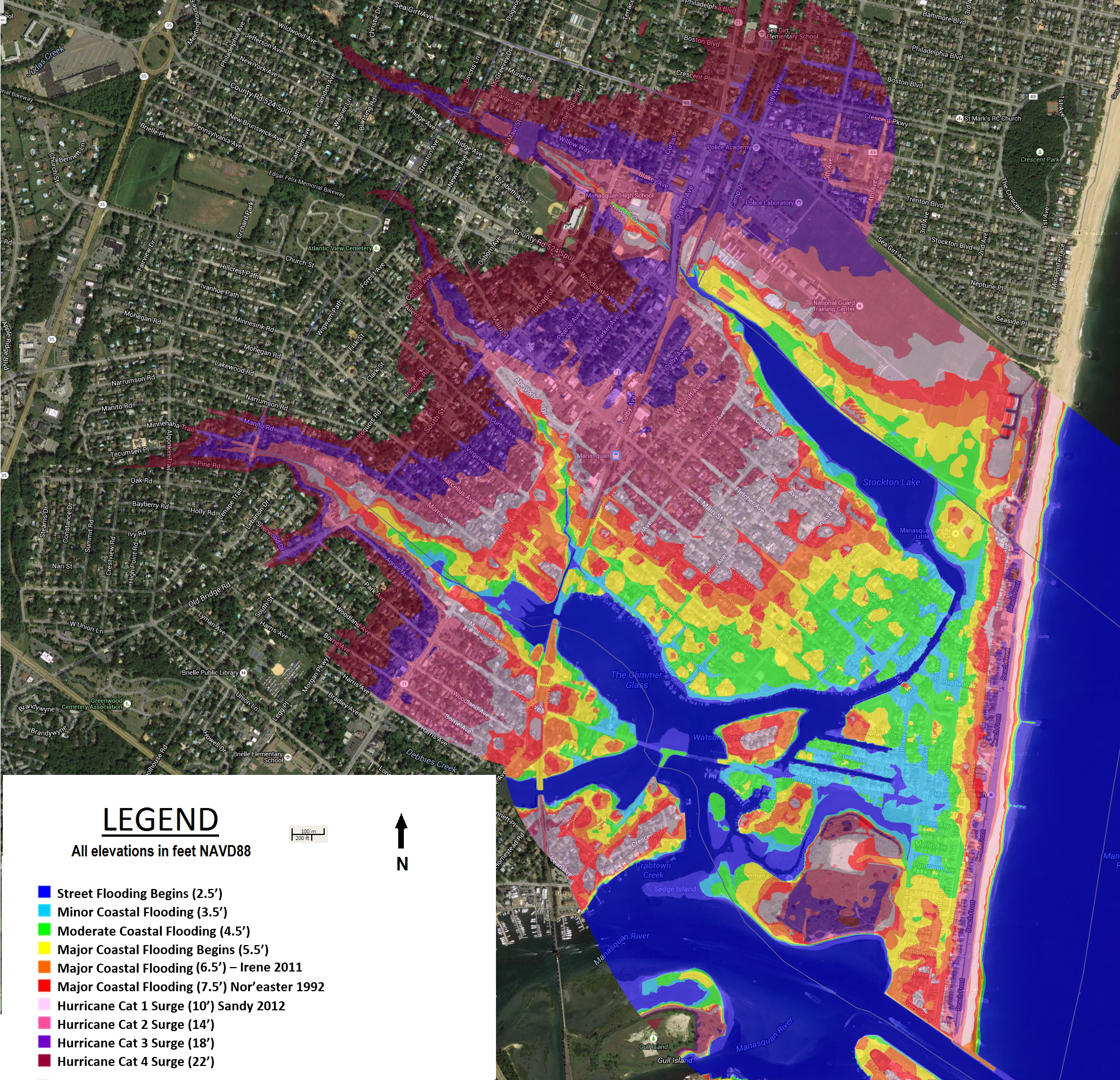
| Flood Stage Levels at Watson’s Creek Gauge in Manasquan: | ||
| Avg. Low Tide: | 0.5’ mllw | -1.8’ NAVD88 |
| Avg. High Tide: | 4.1’ mllw | 1.8’ NAVD88 |
| Minor Coastal Flooding: | 5.7’ mllw | 3.25’ NAVD88 |
| Moderate Coastal Flooding: | 6.7’ mllw | 4.25’ NAVD88 |
| Major Coastal Flooding: | 7.7’ mllw | 5.25’ NAVD88 |
| Hurricane Irene 2011: | 8.3’ mllw | 5.9’ NAVD88 |
| Nor’easter 1992: | 9.4’ mllw | 7.0’ NAVD88 |
| Hurricane Sandy 2012: | 12.3’ mllw | 9.9’ NAVD88 |
Flood Stage Local Impacts:
ACTION STAGE / NEAR FLOOD: Flooding begins on Main Street, Perrine Boulevard, Stockton Lake Boulevard and Brielle Road in Manasquan.
MINOR FLOODING: The following streets in Manasquan begin to flood and become impassable and/or inaccessible to vehicular traffic: Fourth Avenue, Brielle Road, Captains Court, Deep Creek Drive, Glimmer Glass Circle, East Main Street, Long Avenue, Meadow Avenue, Pearce Court, Perrine Boulevard, Pickel Alley, Riddle Way, River Place and Watson Place.
MODERATE FLOODING: The following streets in Manasquan begin to flood and become impassable and/or inaccessible to vehicular traffic: Second Avenue, Third Avenue, Dewey Avenue, East Virginia Avenue, Euclid Avenue, Holly Place, Lockwood Avenue, Marlin Avenue, Ocean Avenue, Pershing Avenue, Pompano Avenue, Rogers Avenue, South Farragut Avenue, Stockton Lake Boulevard, Tarpon Avenue and Warren Avenue. Widespread vehicle flood damage can be expected.
MAJOR FLOODING: The following streets in Manasquan begin to flood and become impassable and/or inaccessible to vehicular traffic: First Avenue, Beachfront Road, Perch Avenue, Pike Avenue, Pine Avenue, Potter Avenue, Riverside Drive, Salmon Avenue, Stockton Avenue, Timber Lane, Trout Avenue and Whiting Avenue. Widespread vehicle flood damage can be expected. Water begins to enter the first floor of low-lying homes and businesses.
To view complete inundation areas for Minor, Moderate and Major flooding, as well as potential hurricane surge inundation areas, visit Manasquan’s Flood Maps or visit the Construction & Code Department at (732) 223-0544 ext. 307 on the second floor of Borough Hall.