
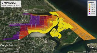
Coastal Flood Levels
Coastal Flood Advisory
When a coastal flood advisory is issued, minor tidal flooding of low-lying areas is expected within 24-hours. If you live in an area prone to tidal flooding, please take the necessary actions to secure property and move vehicles to higher ground. Roadways may become flooded and impassable around the times of high tide, and access onto and off of the beachfront may become limited. Do not attempt to drive over a flooded road or around police barricades. Conditions permitting, utilize First Avenue and the Ocean Avenue Bridge for access off of beach areas. Remember to always follow instructions from police and emergency personnel on our roadways.
Coastal Flood Watch
When a coastal flood watch is issued, moderate or greater coastal flooding is possible within 48 hours. If you live in areas that experience tidal flooding, please take the necessary actions to secure property and move vehicles to higher ground. Roadways may become flooded and impassable for extended periods, and access onto and off of the beachfront may become limited. Do not attempt to drive over a flooded road or around police barricades. Conditions permitting, utilize First Avenue and the Ocean Avenue Bridge for access off of beach areas. Remember to always follow instructions from police and emergency personnel on our roadways. Coastal residents are advised to closely follow the latest forecasts and be prepared to take additional actions should major coastal flooding develop or a coastal flood warning be issued.
Coastal Flood Warning:
“When a coastal flood warning is issued, moderate or greater coastal flooding is expected within 12-hours. If you live in areas exposed to tidal flooding, please take the necessary actions to secure property and move vehicles to higher ground. Roadways will become flooded and impassable for extended periods, and access onto and off of the beachfront will become limited. Do not attempt to drive over a flooded road or around police barricades. Conditions permitting, utilize First Avenue and the Ocean Avenue Bridge for access off of beach areas. Remember to always follow instructions from police and emergency personnel on our roadways. Coastal residents are advised to closely follow the latest forecasts and updates and be prepared to take immediate action to protect life and property if major coastal flooding is forecasted or develops”
Minor Coastal Flooding (3.25’-3.75’ NAVD88):
Tides are forecast to run approximately 2’ above normal, and minor coastal flooding is expected around the times of high tide. The following areas may be affected by this event: Main Street... east of Sims Ave, Pearce and Meadow Ave, River Place, Perrine Blvd, Third and Fourth Avenues and Brielle Road. If you live in areas that are susceptible to tidal flooding, please move vehicles to higher ground before the high tide occurs. Residents should anticipate street flooding along the beachfront approximately 2 hours before and after the times of high tide, and plans should be made in advance should road closures occur.
Minor to Moderate Coastal Flooding (3.75’-4.25’ NAVD88):
Tides are forecast to run approximately 2’ – 3’ above normal, and minor to moderate coastal flooding is expected around the times of high tide. The following areas may be affected by this event: Main Street... east of Lockwood, including Watson, Holly, Pearce & Meadow… Riddle Way and Pickle Alley… Second, Third and Fourth Avenues… Brielle Road, Captains Court and Long Avenue… areas that border the Glimmerglass and Watson’s Creek including River and Perrine… as well as low-lying areas along Stockton Lake. If you live in or near areas prone to tidal flooding, please take the necessary actions to secure outdoor objects and move vehicles to higher ground before the high tides begin. Residents should anticipate street flooding approximately 2-3 hours before and after the times of high tide and Main Street may become impassable for a period of time. Plans should be made in advance should road closures occur.
Moderate Coastal Flooding (4.25’-4.75’ NAVD88):
Tides are forecast to run approximately 3’ above normal, and moderate coastal flooding is expected around the times of high tide. The following areas may be affected by this event: Main Street... east of Lockwood, including Sims, Pershing, Pearce & Meadow… Second, Third and Fourth Avenues… Brielle Road, Deep Creek Drive, Captains Court and Long Avenue… Riddle, Pickle, Tarpon & Pompano Ave… areas within 1 block of the Glimmer Glass and Watsons Creek including all of River, Holly, Watson & Perrine… as well as areas adjacent to Stockton Lake. If you live in or near areas prone to tidal flooding, please take the necessary actions to secure outdoor objects and move vehicles to higher ground before the high tides begin. Residents should anticipate street flooding at least 3 hours before and after the times of high tide and Main Street and Brielle Road may become impassable for a period of time. Plans should be made in advance should road closures occur.
Widespread Moderate Coastal Flooding (4.75’-5.25’ NAVD88):
Tides are forecast to run approximately 3’ – 4’ above normal, and widespread moderate coastal flooding is expected. The following areas may be affected by this event: All areas east of Potter Avenue, including most of the beachfront … all areas within 1 block of the Glimmer Glass and Watsons Creek including River, Perrine, and East Virginia … as well as areas adjacent to Stockton Lake. If you live in or near these areas, please take the necessary actions to secure outdoor property, and move vehicles to higher ground before the high tides begin. Please be advised that all three access roads to the beach, including Main Street, Brielle Road and Ocean Avenue will likely become impassible for a period of time. Widespread street flooding will occur approximately 3 to 4 hours before and after the high tide cycle, limiting access onto and off of beach areas for an extended periods.
Major Coastal Flooding (5.25’-6’ NAVD88):
Tides are forecast to run approximately 4 feet above normal, and major coastal flooding is possible. The following areas may be affected by this event: All areas east of Jackson Avenue, including the entire beachfront … areas within 2 blocks of the Glimmer Glass and Watsons Creek including all of River Perrine, and East Virginia… as well as all areas adjacent to Stockton Lake. If you live in or near these areas, please take the necessary actions to secure outdoor property, and move vehicles to higher ground before the high tides begin. It is recommended that residents in non-elevated structures located in low-lying flood-prone areas, particularly the elderly and special needs persons… shut off the electrical main in their home, and move themselves, vehicles and pets to higher ground until the flooding subsides. Please be advised that all three access roads to the beach, including Main Street, Brielle Road and Ocean Avenue will likely be impassible for several hours. Widespread street flooding may span multiple tide cycles, limiting access onto and off of beach areas for extended periods.
MESSAGE 29: Major Coastal Flooding (6+’ NAVD88):
Tides are forecast to run approximately XX feet above normal, and major coastal flooding is possible. The following areas may be affected by this event: DESCRIBE AREA. If you live in or near these areas, please take the necessary actions to secure outdoor property, and move vehicles to higher ground before the high tides begin. Please be advised that all three access roads to the beach, including Main Street, Brielle Road and Ocean Avenue will likely be impassible for an extended period. Widespread flooding may span multiple tide cycles, limiting access onto and off of beach areas for a long duration.
Pre-Storm Preparations:
Now is the time to complete your preparations. Here are some recommended pre-storm actions:
- Secure outdoor objects
- Fuel up your vehicles
- Charge cell phones and have chargers available
- If you have a generator, make sure it runs and you have adequate fuel on hand
- Have a supply of fresh batteries and flashlights available
- Have a 3-day supply of food, water, medicines and other essentials
- Move valuables to higher ground if you are in a flood zone
- If you or someone you know is elderly, disabled or has special needs, consider arranging for temporary shelter, even if they are not in an evacuation area
- Clean out clogged storm drains & gutters
- Haul out or secure your boat, jetski or small watercraft with extra lines to account for higher tides, wind and wave action
- Review your family emergency plan which should include pets
- Monitor the latest weather forecasts and follow guidance from Emergency Management
- Do not call Police Headquarters unless it is an actual emergency.
- Please visit the Manasquan Flood Information website to view a wealth of information on emergency planning. Stay abreast of the latest forecasts and evacuation orders by subscribing to Manasquan Emergency Alerts, following ManasquanOEM on social media, and continuing to listen to this station, 1620 AM.