
Prepare
Know Your Risks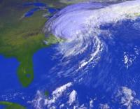
Due to our location along the coast, Manasquan is in the potential path of hurricanes, tropical storms and nor'easters. In addition to coastal storms and coastal flooding, the Borough has the potential to be impacted by flooding/flash flooding, high winds, thunderstorms, tornadoes and winter storm events.
- Please visit the National Weather Service's Safety website for preparedness measures for the many types of severe weather that can impact New Jersey.
- Please visit Manasquan’s Flood Information website for information regarding flood risks in Manasquan.
- Please visit the Monmouth County Sherriff’s Office Know Your Zone website to determine if you are in a pre-planned coastal evacuation zone.
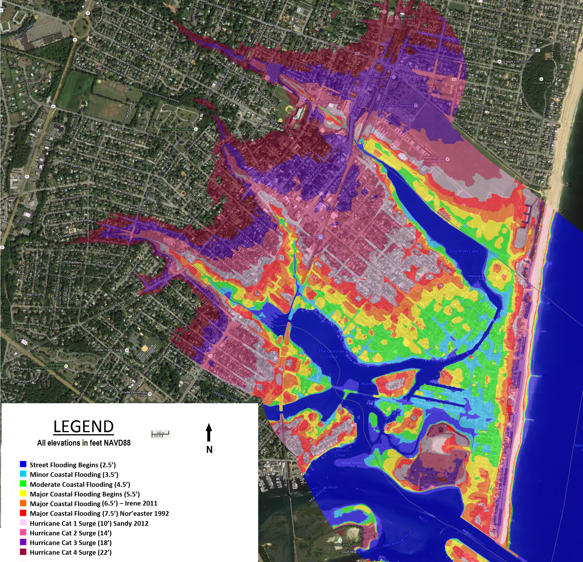
- Visit Manasquan’s Coastal Hazard Viewer to view our coastal flood and hurricane inundation maps online.
Have a Plan
Make sure you have a family emergency plan should severe weather cause travel or essential services to be interrupted. Your plan should include basic safety measures, emergency phone numbers and plans to stay with friends or relatives should an evacuation be ordered.
Have your family learn basic safety measures, such as CPR and first aid; how and when to turn off utilities in your home, and teach children to call 911 during emergencies.
Prepare an emergency supply kit including a 3-day supply of water and non-perishable foods, a battery-powered radio, flashlights with extra batteries, a first-aid kit with prescription medications, special items for infants and the elderly, as well as cash and credit cards.
Preparing and practicing your family plan is your best protection should an emergency occur. For additional information visit FEMA’s ready.gov and NJ OEM’s preparedness websites.
Please visit Manasquan’s Flood Information website for comprehensive information on knowing your flood hazard, flood insurance, flood safety, property protection, how to build responsibly, protecting natural floodplain functions as well as municipal resources available to you on flood protection and mitigation.
Understand Tides and Coastal Flooding
Although Manasquan is susceptible to a variety of severe weather hazards, we are especially vulnerable to coastal flooding due to our geography and proximity to the coast. The overall tide that we see in Manasquan is made up of several factors:
Lunar Tide:
Daily tide cycles are based upon a complex interaction between the sun and moon’s gravitational pull on the earth. This results in two daily high and low tides, each spaced approximately 6 hours apart. Depending on the lunar phase, the high tides range between 3.5’ and 5.5’ higher than the low tides.
Storm Surge:
Storm surge is a result of three varying factors, including wind, waves and barometric pressure. Each variable has an important role in overall storm surge.
Tide levels can reference North American Vertical Datum of 1988 (NAVD88) or relative mean lower low water (mllw). The National Weather Service commonly issues warnings in mean lower low water datum (mllw). To convert from NAVD88 to mllw, add 2.4’. To convert from mllw to NAVD88, subtract 2.4’.
Types of Coastal Flood Warnings:
Coastal Flood Advisory: Coastal flood advisories are issued when minor coastal flooding is expected or is occurring in the advisory area.
Coastal Flood Watch/Warning: A coastal flood watch is issued when moderate or greater coastal flooding is expected to occur in the watch area if weather develops as expected. A coastal flood warning is issued when coastal flooding is occurring, is imminent or is expected in the warned area within 12 hours.
Flood Stage Levels at Watson’s Creek Gauge in Manasquan: | ||
Avg. Low Tide: | 0.6’ mllw | -1.8’ NAVD88 |
Avg. High Tide: | 4.2’ mllw | 1.8’ NAVD88 |
Minor Coastal Flooding: | 5.7’ mllw | 3.25’ NAVD88 |
Moderate Coastal Flooding: | 6.7’ mllw | 4.25’ NAVD88 |
Major Coastal Flooding: | 7.7’ mllw | 5.25’ NAVD88 |
Hurricane Irene 2011: | 8.3’ mllw | 5.9’ NAVD88 |
Nor’easter 1992: | 9.4’ mllw | 7.0’ NAVD88 |
Hurricane Sandy 2012: | 12.3’ mllw | 9.9’ NAVD88 |
Flood Stage Local Impacts:
Near Flood: Flooding begins on Main Street, Perrine Boulevard, Stockton Lake Boulevard and Brielle Road in Manasquan.
Minor Flooding: The following streets in Manasquan begin to flood and become impassable and/or inaccessible to vehicular traffic: Fourth Avenue, Brielle Road, Captains Court, Deep Creek Drive, Glimmer Glass Circle, East Main Street, Long Avenue, Meadow Avenue, Pearce Court, Perrine Boulevard, Pickel Alley, Riddle Way, River Place and Watson Place.
Moderate Flooding: The following streets in Manasquan begin to flood and become impassable and/or inaccessible to vehicular traffic: Second Avenue, Third Avenue, Dewey Avenue, East Virginia Avenue, Euclid Avenue, Holly Place, Lockwood Avenue, Marlin Avenue, Ocean Avenue, Pershing Avenue, Pompano Avenue, Rogers Avenue, South Farragut Avenue, Stockton Lake Boulevard, Tarpon Avenue and Warren Avenue. Widespread vehicle flood damage can be expected.
Major Flooding: The following streets in Manasquan begin to flood and become impassable and/or inaccessible to vehicular traffic: First Avenue, Beachfront Road, Perch Avenue, Pike Avenue, Pine Avenue, Potter Avenue, Riverside Drive, Salmon Avenue, Stockton Avenue, Timber Lane, Trout Avenue and Whiting Avenue. Widespread vehicle flood damage can be expected. Water begins to enter the first floor of low-lying homes and businesses.
To view complete inundation areas for Minor, Moderate and Major flooding, as well as potential hurricane surge inundation areas, visit Manasquan’s Flood Maps or visit the Construction & Code Department at (732) 223-0544 ext. 307 on the second floor of Borough Hall.
Monitor Water Levels
Manasquan’s flood monitoring and forecasting system was developed through a partnership with the National Weather Service, USGS and Stevens Institute. The system has the ability to alert residents when coastal flooding is predicted or when a pre-determined flood height has been exceeded.
Manasquan’s Flood Advisory System:
Know in advance when flooding is forecast by signing up for Manasquan’s new flood advisory system! Manasquan has partnered with Stevens Institute’s Davidson Laboratory in utilizing their Flood Advisory System and has developed warning thresholds for Manasquan residents. This system will warn you when significant coasdtal flooding is possible within 72 hours.
 This system has been integrated into Manasquan's new notification system and can be accessed by simply subscribing to "Flood Warnings." You can choose whether you would like text, email or telephonic notifications of these flood warnings. Alternately, resident's can visit Stevens website and enter their email where it says “Manage Email Notifications” and select “Watson Creek at Manasquan” as your site.
USGS High Tide Alerts:
Manasquan’s tide gauge can also send wireless alerts to your cell phone or email to notify you that flooding is occurring…
- Visit the USGS Tide Gauge for Manasquan website.
- Visit the USGS WaterAlert Registration page.
NOAA Weather Radio
Residents are encouraged to purchase a NOAA weather radio for their home or business. NOAA weather radio is a public service provided by both the National Weather Service and the Emergency Alert System, enabling your weather radio to be a single source for comprehensive weather and emergency information.
For additional information on NOAA weather radios, visit the National Weather Service.
Manasquan’s Public Warning Systems
Manasquan utilizes multiple, redundant modes to communicate critical warning and evacuation information to our residents.
Please visit our Public Warning page to familiarize yourself with the different ways to receive evacuation and emergency information.